

Badrinath Location
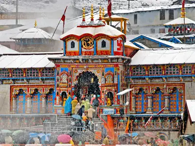
Badrinath is a Hindu holy town and a nagar panchayat in Chamoli district in the state of Uttarakhand, India. It is located at an elevation of 11204 feet (3415 mts), in the shadow of Nilkanth Peak and between Nar-Narayana Hills, Badrinath is a holy hindu pilgrimage situated on the banks of Alaknanda river.
Coordinates of Badrinath: 30.73°N 79.48°E.
How to Reach Badrinath
By Air
The nearest airport from Badrinath is the Jolly Grant Airport near Dehradun, about 317 km from Badrinath.
By Helicopter
The distance by a helicopter journey is hardly 100 km. There are many providers of helicopter service from Dehradun to Badrinath.
By Train
The nearest railway stations to Badrinath are at Rishikesh (297 kms), Haridwar (324 kms) and Kotadwar (327 kms). Rishikesh is not connected by fast trains and Kotadwar has very less number of trains. Thus Haridwar serves as the best railway station if you are visiting Badrinath by train. Haridwar is connected by many trains from all part of India.
By Bus
Badrinath is easily accessible by road. It is located at a distance of 525 Km from Delhi & 296 Km from Rishikesh. There are regular buses operating to Badrinath from Delhi, Haridwar and Rishikesh.
Regular buses operate from Rishikesh bus station to Badrinath and start very early before dawn. The last bus from Rishikesh leaves for Badrinath before dawn. The road is narrow after Joshimath and travel is not permitted on the road after sunset. Therefore if one misses the bus for Badrinath at Rishikesh bus station, one has to go only up to Rudraprayag, Chamoli or Joshimath and spent the night there to take the early morning bus for Badrinath from that town.
Road Connectivity
Well connected to Haridwar , Rishikesh, Dehradun , Dev Prayag, Rudra Prayag, Kotdwar, Joshi Math and other hill stations of Garhwal and Kumaon region.
Badrinath on Google Map
Road Route Map to Badrinath
Route 1 – Haridwar/Rishikesh To Badarinath (324 km), Rishikesh To Badarinath (298 km)
Haridwar – (24 km) Rishikeh – (71 km) Deoprayag – (30 km) Kirtinagar – (4 km) Shrinagar – (34 km) Rudraprayag – (20 km) Gauchar – (12 km) Karnaprayag – (20 km) Nandprayag – (11 km) Chamoli – (8 km) Birahi – (9 km) Pipalkoti – (5 km) Garur Ganga – (15 km) Helang – (14 km) Joshinath – (13 km) Vishnuprayag – (8 km) Govindghat – (3 km) Pandukeshwar – (10 km) Hanumanchatti – (11 km) Shri Badarinath Ji.
Route 2 Kedarnath To Badarinath via Chopta (229 km)
Via Guptakashi – Ukhimath – Chopta – Gopeshwar – Chamoli – Pipalkoti
Kedarnath to Kund (53 km route is same as given in the Route 1D chart) – (6km) Ukhimath – (22 km) Dogalbhitta – (7 km) Chopta – (27 km) Mandal – (8 km) Gopeshwar – (10 km) Chamoli – from Chamoli to Badarinathji (96 km)
Route 3: Kedarnath To Badarinath (247 km)
Kedarnath – (14 km trek) Gaurikund – (5 km) Sonprayag – (4 km) Rampur – (9 km) Phata – (14 km) Guptkashi – (7 km) Kund – (19 km) Agastyamuni – (8 km) Tilwara – (8 km) Rudraprayag – (20 km) Gauchar – (12 km) Karnaprayag (20 km) Nandprayag – (11 km) Chamoli – (8 km) Birahi – (9km) Pipalkoti – (5 km) Garur Ganga – (15 km) Helang (14 km) Joshimath – (13 km) Vishnuprayag – (8 km) Govindghat – (3 km) Pandukeshwar – (10 km) Hanumanchatti – (11 km) Shri Badarinath.
Badrinath Distance Chart
| Starting Points | Destinations | Distance |
|---|---|---|
| Rishikesh | Badrinath | 301 kms |
| Gaurikund (near Kedarnath) | Badrinath | 233 kms |
| Kotdwar | Badrinath | 327 kms |
| Delhi | Badrinath | 525 kms |
| Jaipur | Badrinath | 801 km |
| Kolkata | Badrianth | 1719 km |
| Pune | Badrinath | 1947 km |
| Bangalore | Badrinath | 2495 km |
| Auli | Badrinath | 34 km |
| Valley of Flowers | Badrinath | 70 km |
| Kasauni | Badrinath | 201 km |
| Almora | Badrinath | 243 km |
Badrianth Facts
- Area3 sq kms
- Altitude3133 mts
- DistrictChamoli
- StateUttarakhand
- SeasonApril to November
- Famous forPilgrimage, Temple
- Pincode246422
- STD Code01381
